


Természetjáró, a túratervező
Természetjáró, a túratervező의 설명
등산객, 자전거 타는 사람, 트레일러너, 암벽 등반가 및 수상 스포츠 애호가를 위해 특별히 개발된 헝가리의 온라인 관광 가이드는 내장된 투어 플래너뿐만 아니라 수백 개의 추천 투어와 수천 개의 명소를 모두 자세한 설명과 풍부한 사진과 함께 제공합니다. , 대화형 지도에서 편안하게 볼 수 있습니다. 확장된 기능을 위한 구독 옵션과 함께 무료로 제공됩니다.
기능
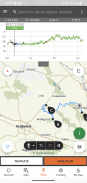
• 표시된 모든 트레일이 포함된 다양한 대화형, 확대/축소 가능, 벡터화된 세계 하이킹 지도로 현재 위치를 보여줍니다.
• 지도에서 나만의 여행을 계획하고 길이, 기간, 고도 프로필을 즉시 얻을 수 있는 편리한 방법
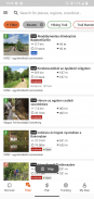
• 실용적인 데이터, 근처 최고의 명소에 대한 자세한 설명, 자연 및 문화적 배경, 양질의 사진 및 가는 방법에 대한 정보가 포함된 등산객, 자전거 타는 사람, 트레일 러너 및 카누 타는 사람을 위한 천 개 이상의 추천 투어
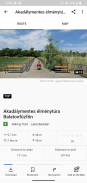
• 전망대, 자연 파노라마 지점, 삼림 열차, 요새, 박물관을 포함한 수천 개의 헝가리 추천 명소에 대한 자세한 설명, 양질의 사진, 가는 방법에 대한 정보 제공
• 표시된 산책로 근처의 오두막, 관광 호텔, 아파트를 포함한 수백 개의 숙박 시설
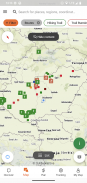
• 지도 보기가 포함된 유용한 컬렉션: 발라톤 호수 주변 해변, 아이스 스케이트 경기장, 식물원, 최고의 트레일 달리기 코스, 암벽 등반 장소, 장애인을 위한 투어 등.
• 공지, 경고 및 폐쇄
• 오프라인 사용을 위해 지도 섹션, 투어 및 명소 다운로드
• 실시간 고도 프로필 및 음성 안내를 통해 경로를 따라 즉시 내비게이션
• 경로를 기록하세요
• BuddyBeacon: 실시간으로 친구들과 위치를 공유하세요.
• 공식 구간과 경로, 관심 장소 및 숙박 시설이 포함된 전체 헝가리 블루 투어
• 컴퓨터와 앱을 실행하는 휴대기기 간에 모든 콘텐츠를 동기화하세요.
• 지역 일기예보를 확인하세요.
• 3D 비행: 투어의 가상 조감도
• 현재 위치를 알려주는 피크 파인더(스카이라인) 및 나침반과 같은 유용한 도구 내장
• 커뮤니티 서비스: 콘텐츠를 평가하고 친구들과 공유하세요.
Google의 WEAR OS가 탑재된 스마트시계
스마트워치를 한눈에 보면 지도에서 GPS 위치에 대한 정보를 얻을 수 있습니다. 트랙을 기록하고, 추적 데이터를 얻고, 경로를 따라 탐색할 수 있습니다. 앱 타일을 사용하면 근처 경로에 쉽게 접근할 수 있습니다.
Pro 회원 전용
어디서나 이동 가능: Outdooractive Pro는 모바일 및 데이터 신호 없이 오프라인으로 작동합니다. 무제한 목록도 생성할 수 있으며 앱에는 광고가 없습니다. 또한 위성 이미지, 30개 이상의 활동 트레일 네트워크가 포함된 독특한 Outdooractive 지도, 다음 제공업체의 공식 지형 지도를 볼 수 있습니다.
영국 병기 조사, Landranger, Explorer
뉴질랜드 토지 정보
유타 USGS
독일 BKG
오스트리아 BEV
스위스 스위스토포
프랑스 IGN
스페인 CNIG
이탈리아
네덜란드 PDOK
노르웨이 Kartverket
덴마크 Kortforsyningen
스웨덴 Lantmäteriet
핀란드 국토 조사
일본 GSI
세계 지도
Pro+ 회원 전용
Pro+에는 알파인 협회의 공식 지도와 KOMPASS의 프리미엄 지도도 포함되어 있습니다.
질문이나 제안 사항이 있으면 다음을 방문하십시오.
https://www.termeszetjaro.hu/hu/p/gyakran-ismetelt-kerdesek/41050512 /
데스크톱 버전:
https://www.termeszetjaro.hu/
Facebook에서 우리를 팔로우하세요:
https://www.facebook.com/Termeszetjaro.hu/
연락처:
termeszetjaro@termeszetjaro.hu
TEKA 카드에 대한 추가 정보:
http://www.termeszetjarokartya.hu/
Természetjáró, a túratervező - APK 정보
APK 버전: 3.20.3패키지: com.outdooractive.mtszTermészetjáró, a túratervező의 최신 버전
다른 버전들


동일 카테고리의 앱


